Another year, another section hiked on the AT. Picking up where we left off last year, Nantahala Outdoor Center, all six of us headed UP into the woods and followed what is affectionately known as "the green tunnel."
Day One: NOC - Sassafras Gap Shelter 7 miles (142 total AT miles)
Tricia and the girls were joining us for our first day of hiking. The plan was to hike in seven miles to the first shelter together and then part ways the following morning - the boys and I heading on and Tricia and the girls heading back down to the car. That first day was a doozy. We gained 1700 feet in elevation in just two miles. It was tough going for each of us. There was a lot of encouragement, plenty of rest stops, and buckets of sweat. I think we were all thankful for the relatively cool mountain air because down in the gap the temperature would reach into the nineties.

One concern I had about this first day, outside of the really challenging climb, was the fact there were no water sources listed between the gap and our shelter. Seven miles is a long way to go with no water sources when you walk as slowly as we do. We generally average about a mile per hour including the various breaks we take to catch our breath, climb on a fallen tree, or reach for a midday snack. A few hours in we were all very low on water when Muluken noticed a small trickle falling down the rocks at the side of the trail. We were very excited. We all chugged what little was left of our bottles and patiently waited for them to fill up again. I treated the water with my Steripen and we were good to make the final few miles into camp.

Soon after we would get all the water we could ever want. Storm clouds moved in above us and a steady rain began to fall. We all stopped to put on our pack covers and Ainsley pulled on her rain jacket. The rest of us chose to let the rain cool us off a bit. It was refreshing and didn't last all that long. By the time we reached Sassafras Gap Shelter we were already dry - and relieved. The shelter was a bi-level structure with a small cooking/eating platform in the front. Alone, we unpacked our things and made ourselves at home.
 |
| Harper and Ainsley share a laugh. |
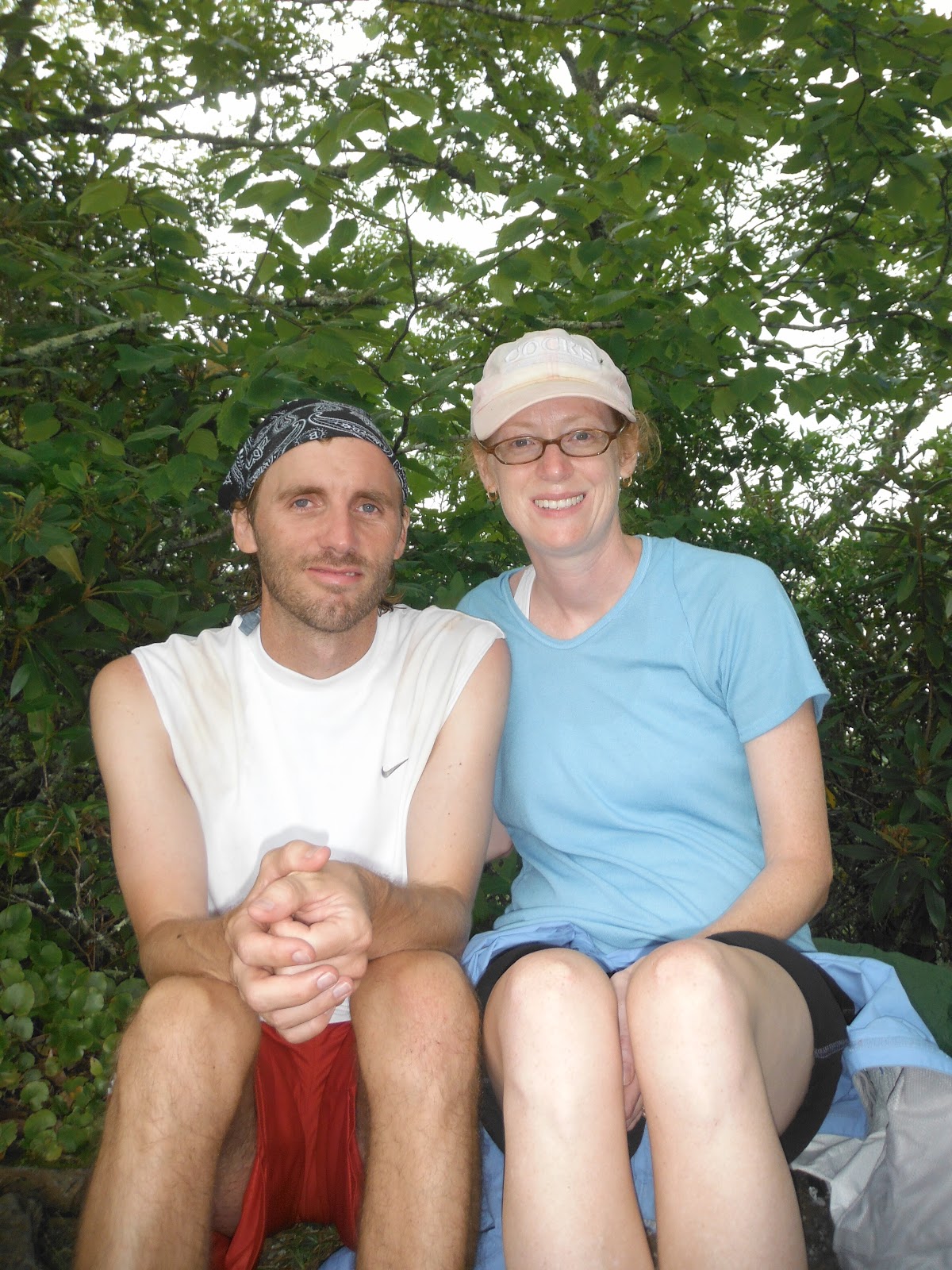
 |
| Tricia and I enjoy a short break. |
 |
| Three of the kids playing cards on the upper sleep platform. |
|
 |
| While they played cards, Ainsley wrote about her day in her journal. |
 |
| Three pots, two cans of fuel, and a few Mountain House dinners. You can see the straps of my pack hanging down from above. This did not prevent the shelter mice from rummaging through my pack. They chewed up a Jet Boil lid (which should have been hanging in the bear bag) and left a tiny "present" in the bottom of one of my pockets. |
Day Two: Sassafras Gap Shelter - Cable Gap Shelter 15 miles (157 total AT miles)
Throughout the night we heard a variety of interesting noises. It's normal to hear the symphony of bugs buzzing once the sun sets. What is not so normal is to hear a loud screaming noise followed by the breaking of branches and crunching of sticks as something seemingly large comes storming down the mountain. I'm not certain what it was (a cub maybe?) but it definitely woke most of us up. Surprisingly, no one mentioned this until the next morning. Everyone just silently went back to sleep.
Once we were all packed up for our hikes the girls began crying because they didn't want us to leave. Ty had been in tears the night before claiming he did not want to hike anymore and wanted to go home. This was the end of his hike of the AT in its entirety. Muluken was silent. This was not the start I envisioned for the trip. I offered Muluken the opportunity to choose whether or not he wanted to do this trip and he responded "I'm NOT quitting. I want to hike." So hike we did. We gave our last hugs and, feeling like a terrible dad, I pulled away from the girls and headed off in the opposite direction. Just a few yards up the trail I called back "Hey, we left you a message on the trail. Be sure to look for it!"
 |
| The day before Muluken and I collected fallen flowers and made a heart for the girls. After a few hours of hiking they found it. It was still perfectly in tact. We might be lugheads most of the time but we can be sweet too. |
Muluken and I soon found our stride. We were really making great time up and down the trail. We decided to stretch our planned eleven mile hike to fifteen miles. We were hoping to have a shorter hike the following day into Fontana Dam because we knew there'd be ice cream and soda. I don't really care that much for soda but somehow knowing you can't have something makes you want it all the more.
We stopped for the night at Cable Gap Shelter. We really were at the bottom of a deep gap. The shelter was small and dark - requiring a headlamp even before dusk. We ate our dinner (dehydrated ratatouille), brushed our teeth, hung all scented items over a distant tree, and climbed into the shelter for a game of rummy. I won. By a lot.
Day 3: Cable Gap Shelter - Fontana Dam Shelter 6 miles (163 total AT miles)
We were up at 6am and on the trail by 7. That's a bit of a slow start but with a short day ahead of us there was no need to hurry. It seems whenever we work ahead to get a short day - thinking this will make for an easy day - it always backfires. Short days seem to go slower, I guess because our focus shifts from the walking to the destination. This is a big no-no.
Our first climb was grueling - not so much because it was long or steep but because we were both a bit groggy and anxious. However, a few hours into the hike we each woke up and our legs loosened. Along the way we came across many trees that had been hollowed out. I talked Muluken into climbing into one to see if he could fit. It was tight with the backpack but he made it in with a few pushes from behind.
The last three miles were all downhill. Going downhill is the worse part of hiking. Your toes all get crunched into the front of your shoes and the impact on your knees really begins to take its toll. By the end of this descent I had the beginnings of five blisters and a spiking pain on the outside of my right knee.
The pain was worth it though. We hit the bottom, crossed a road, and walked into Fontana Dam. There was a bathroom, a phone, and a soda machine. After some small talk with two other hikers I made my way into the bathroom to wash my hands and face. It felt great. After a little more small talk I filled out our backcountry permits for the Smokies and we walked the final one mile into the shelter. We were excited because the Fontana shelter is known to hikers as the "Fontana Hilton" because it is so nice.
 |
| This shelter was amazing. Not only beautiful and clean, it was huge. We had it all to ourselves for the night. Only a hundred yards away was a bathroom with running water and a shower. This is all located on TVA land. TVA uses the dam to create electricity which it then sells to regional electric companies. |
 |
| We met these two fellas as we came out of the woods. They had been hiking just ahead of us the past two days. |
|
 |
| Here is Fontana Lake. It sits at the base of the Smokies (seen at the top left). The water is remarkably clear. |
 |
| As promised, the visitor center had ice cream bars. |
 |
| A small path beside the shelter led down to the lake. Someone had tied a rope to the trunk of a tree to help ease down the steep grade leading to the water's edge. |
 |
| Refreshing! |
 |
| We enjoyed playing underwater with the new waterproof camera. As we hike north we will encounter many more trailside lakes and rivers. |
There was a lot of talk about a bear cub who had been hanging around the dam. According to a maintenance worker, the cub was abandoned by its mother last year but survived the winter alone. We were told it was very small but to be careful should we sight it - it might walk right up to us to get food. Later that night as we sat playing cards at a picnic table beside the lake a car pulled up and an older gentleman climbed out and walked over to us. He told us he was looking for a bear he had seen a few nights ago sitting on a small rock wall just beside where we were playing. He showed us photos of it on his phone and it was definitely the cub we had been warned about. As we headed back to the shelter we were glad we had chosen to sleep on the upper platform. We pretended we didn't know that bears are really good climbers.
Day 4: Fontana Dam Shelter - Mollie's Ridge Shelter 11 miles (174 total AT miles)
The day's hike was much easier than expected. Though there were a number
of decent climbs we marched along quite easily. We found that a great
attitude and careful pacing make all the difference. This was a great day of hiking.
 |
| We crossed over the top of the dam and made our way into the Smoky Mountains. |
|
 |
| We were both very excited to get into GSMNP. However, I was a bit intimidated by the climbing I knew lay ahead of us. We would be gaining more than 2000 feet of elevation. |
 |
| One of the things we noticed about the Smokies is that they have a lot more sings letting you know how far you are from various trails and shelters. There was also a sign at the entrance to the park about a day hiker who had gone missing last March. That was a bit unsettling. |
|
 |
| Speaking of signs, we saw this one posted a number of times throughout the next few days. Evidently it is not advised to approach a bear. Go figure. Still, we REALLY wanted to see one. |
 |
| This was typical of the trail for the first day in the Smokies. About twenty miles ahead the trail would drastically change. |
 |
| We counted more than ten piles of bear scat on the trail during the day. Most were much larger than this one and did not contain so many undigested berries. This particular fellow must have been having stomach issues. |
When we reached the shelter it was only about five o'clock in the afternoon. We were rained on during the last two miles of our hike and came into the shelter absolutely drenched and shivering. We changed into dry clothes, slid into our sleeping bags, and played a few rounds of poker while waiting to warm up. Around this time Muluken admitted he was homesick. Because of a baseball tournament, he had been away from the family for the past twelve days while we were in St. Louis. A long hike immediately after this separation was probably not the best planning. We decided to hike a long day tomorrow (17 miles) and then do another 12 the following day to get into Gatlinburg. We'd stay in a motel there, resupply, and head back out for two more days before getting picked up as we exited the Smokies. This would shorten our projected hike by about five days but only thirty-five miles.
Day 5: Mollie's Ridge Shelter - Clingman's Dome Observation Tower 22 miles (196 total AT miles)
 |
| We left the shelter early to get a head start on what we anticipated to be a long day of walking. We had never walked 17 miles before and weren't positive how long it might take us. |
 |
| The rising sun peeks through the trees. |
 |
| Muluken pretends to be asleep on a nice rock chair. |
 |
| We don't dare eat most the things we find growing alongside the trail but blackberries we know are safe - and yummy. |
 |
| Over the past two years we've seen a lot of different types of mushrooms. Many of them we have photographed. Can you believe the Smokies are home to more than 2,000 varieties of mushroom. |
 |
| A rare toad sighting. What we see most are centipedes, millipedes, and snails. We paid close attention to the birds we heard today. If you listen carefully you can identify a pattern to their songs. Pretty soon Muluken was excitedly sharing patterns he noticed coming from above. |
 |
| Our clothes were still wet from hiking in the rain yesterday. When we reached Rocky Top (the subject of the famous song) we took off our shoes and socks and lay them out to dry. Due to the cloud cover it didn't work. |
 |
| We passed a log that had the official AT emblem carved into it. There's talk of getting AT tattoos when we finish the trail. |
Due to a shady character we encountered at the shelter we planned to sleep in for the night, we wound up hiking an extra six miles in the dark and the rain, getting lost, and sleeping exposed to the pouring rain with fifty mph winds snapping our bags this way and that. We hiked this extra distance with three guys we met earlier in the day. One began to collapse from exhaustion, another was certain he had broken his toe, and the other fell multiple times while trying to carry not only his own pack but his sick buddies as well. It was a long night - but an adventure.
Day Six: Clingman's Dome Observation Tower - Newfound Gap 8 miles (204 total AT miles)
 |
| After a long terrible night we were rewarded with a beautiful sunrise. |
 |
| A coniferous rainforest, the top of Clingmans Dome is home to many dying trees. This is due to the balsam wooly adelgid - an insect introduced from trees imported from England. |
Muluken and I hiked eight miles through Frazier firs to Newfound Gap. My feet were killing me from all the rocks and the multiple blisters that had been rubbed raw the evening before. I knew as we hiked into the gap we were going to have end our hike for the year. There had been enough drama, misfortune, and injury for one year. Never before had we had a hike where so many things seemingly worked against us. Still, we had fun and passed the 200 mile mark of our journey toward Maine. Next year we'll finish the Smokies and make our way into Hot Springs, North Carolina. That will put us about 1/8 of the way to finishing the trail. Ha, there's a lot of hiking still ahead.
 |
| Finishing up at Newfound Gap. Fitting it should be raining. Unable to get a shuttle or cell phone reception, we hitchhiked into Gatlinburg. Backpackers hitch a ride into town from this gap all the time so finding a ride was not all that difficult. |
|
 |
| Within a few hours Tricia and the other kids were in the van and driving up to get us. We all had dinner, stayed the night in a motel, and spent the next morning doing small hikes in the Smokies as a whole family. A perfect ending! |